GEOG 5, Lab 12: Coastal Geomorphology
Hello, dear friend, you can consult us at any time if you have any questions, add WeChat: daixieit
Lab 12: Coastal Geomorphology
GEOG 5
This lab will examine coastal geomorphology and reflect on the big takeaways from the course. In part 1, you will identify coastal landforms resulting sediment transport, erosion, and deposition. Part 2 involves examining sea level rise using an online resource by NOAA (National Oceanic & Atmospheric Administration). In Part 3, you will reflect on what you learned from the labs and the course.
Part 1: Identifying Coastal Landforms
In this part of the lab, you will identify coastal landforms that result from sediment transport by the longshore current and submergent/emergent shorelines.
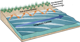
Sediment moves along a shoreline by two primary processes: the longshore current and beach drift. Longshore currents are ocean currents that move parallel to the shore yet approach the shoreline at a slight angle (see figure below). Longshore currents drag water down the length of the beach in the same direction the wind is blowing. Beach drift also carries sand and sediment along the shoreline. As waves wash on and off the beach, they transport sediment and sand with them in a zigzag-like movement.
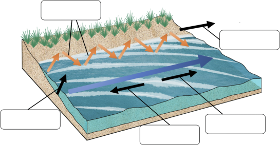
1. Label the figure below with the following terms: beach drift, net movement of sand grains, upstream of the longshore current, downstream of the longshore current, and incoming wave direction. (2.5 pts)
2. What is the path of sand and sediment particles along a coastline? (0.5pts)
3. Based on this movement of sand and sediment particles, how might a beach form along a coastline? (0.5pts)
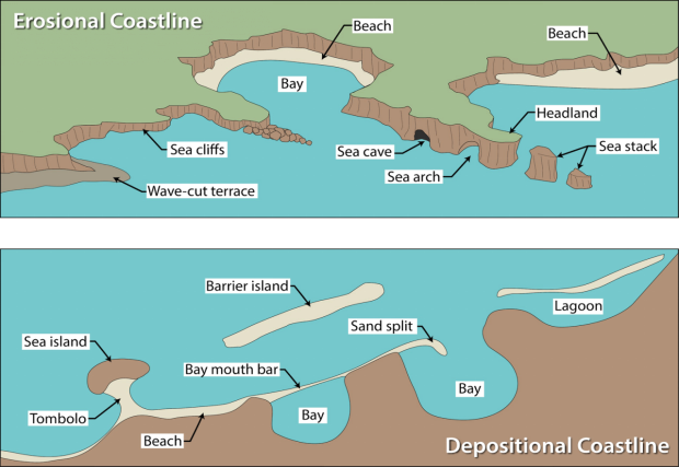
Emergent coasts occur where sea levels fall due to tectonic uplift or ice ages. Emergent coasts are also called erosional coasts. Some features associated with emergent coasts include high cliffs, headlands, exposed bedrock, steep slopes, rocky shores, arches, stacks, tombolos, and wave platforms. In emergent coasts, wave energy, wind, and gravity erode the coastline. The erosional features are elevated relative to the wave zone. Sea cliffs are persistent features as waves cut away at their base and higher rocks calve off by mass wasting. Refracted waves that attack bedrock at the base of headlands may erode or carve out a sea arch, which can extend below sea level. When a sea arch collapses, it leaves a rock column called a stack.
Submergent coasts are also known as depositional coasts. Submergent coasts occur where sea levels rise due to tectonic subsidence—when the Earth’s crust sinks—or when sea levels rise due to glacier melt. Features associated with submergent coasts include river mouths, fjords, barrier islands, lagoons, estuaries, bays, tidal flats, and tidal currents. In submergent coastlines, river mouths are flooded by the rising water.As sediments travel along the longshore current and are deposited, long ridges called spits extend parallel to the coastline.
Explain how each of the following emergent shoreline landforms are formed:
4. Sea stacks: (0.5pts)
5. Sea caves: (0.5pts)
6. Sea cliffs: (0.5pts)
Explain how each of the following submergent shoreline landforms are formed:
7. Bay mouth bar: (0.5pts)
8. Lagoon: (0.5pts)
9. Sand spit: (0.5pts)
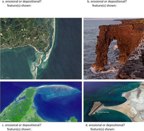
10. For each of the four photographs shown below, indicate whether the coastline is erosional or depositional and identify the landform(s) shown on the photographs. (2 pts)
Part 2: Examining Sea Level Rise
For this part of the lab, you will examine the potential effects of rising sea level at a location in the U.S. using NOAA’s Sea Level Rise Viewer. To begin, do the tutorial (direct link: https://coast.noaa.gov/elearning/ localscenarios/) on Ship Bottom, New Jersey in order to learn how to use the viewer and better understand the information that it conveys. This should take approximately 5-10 minutes. Once you’ve finished the tutorial, go to the Sea Level Rise Viewer (direct link: https://coast.noaa.gov/slr/) and choose a coastal area in the U.S. to study (e.g., southern California, Puerto Rico, southern Louisiana, etc.). Note that only those areas of the country that will be directly impacted by rising sea level can be chosen for this assignment.
Once you have zoomed into the area you’re studying, select “Local Scenarios” from the left-side menu bar and click on the map pin closest to your area of interest. Select the Intermediate High Scenario and zoom into an urban area that is shaded in bright green.
**NOTE: In the past, some students have reported issues with the Sea Level Rise Viewer tool working correctly when they tried to do this assignment. If you run into this problem, first make sure you're accessing it in Chrome or Firefox using a laptop/desktop computer (not a tablet or phone). If you still run into issues, you can use the Surging Seas online maps (direct link: https://sealevel.climatecentral.org/maps/) information instead.**
11. What community are you studying? (0.5pts)
12. What water height will this community experience a level of inundation of water that is likely to be of concern? Describe what areas of the community may be impacted. (1 pt)
13. Select Mapping Confidence from the left-side menu and describe how much certainty exists in this prediction of how sea level rise will impact the community you’re studying. Are there areas within the community for which there is a high level of certainty that this inundation will occur? Describe what areas of the community may be impacted. (1 pt)
14. Click on High Tide Flooding from the left-side menu to see the increased risk for flooding in this community. Are there areas within the community for which there is a concern for increased flooding related to higher tides? Describe what areas of the community may be impacted. (1 pt)
Part 3: Final Reflections
In this course, we have studied the four environmental spheres (atmosphere, hydrosphere, biosphere, and lithosphere) and how these spheres interact. In other words, we have studied the world from the perspective of Physical Geography.
In many of the labs, you were asked to choose a location (in California, the U.S., or anywhere in the world), and use the course materials to enhance your understanding of that place. For this last part of the last lab, reflect on what you learned from this course, especially regarding the places that you live or interest you.
For the following two questions, you will be graded on the depth of your reflection since there is no “right” or “wrong” answer for reflection-type questions.
15. Reflecting on the labs and resources provided in the labs: What did you learn about the place or places you chose to study for the labs? Did you find it interesting or helpful to apply what you learned in the class to investigating a place you know? Why or why not? How might this information be useful to you in the future, or do you feel that this information will not be something that you find relevant in the future? Explain. (3 pts)
16. Reflecting on the overall course: Aside from fulfilling a requirement and earning a grade from the course, what did you get out of this course in Physical Geography? Are you interested in taking future courses in Geography? What do you think you will remember about this course a year from now? (3 pts)
2025-12-13