GGR201H5F Practical Exercise 2: Landscapes of Southern Ontario Part (ii)
Hello, dear friend, you can consult us at any time if you have any questions, add WeChat: daixieit
GGR201H5F
Practical Exercise 2: Landscapes of Southern Ontario
Part (ii) The Guelph Drumlin Field
Fall 2025
Due: Friday 7th November, 9 pm
Outline & rubric
|
Practical class |
Assignment component |
Mark |
|
October 10th |
Part (i) Glacial landforms in the Peterborough area of Southern Ontario. Section 1 - topographic profiles Section 2 - geomorphological mapping |
15 15 |
|
October 17th |
Part (ii) The Guelph Drumlin Field. Section 3 - geomorphological mapping and virtual fieldwork Section 4 - report on glacial streamlining and ice flow direction |
20 20 |
|
October 24th |
Part (iii) Fluvial landscapes of the Grand River valley, Brantford. Section 5 - River planforms and sinuosity Section 6 - Palaeochannels of the Fairchild Creek |
15 15 |
|
October 31st |
No classes |
|
|
November 7th |
Parts (i-iii) (continued) Online submission by 7th November, 9 pm |
|
|
|
Total: |
100 |
Introduction:
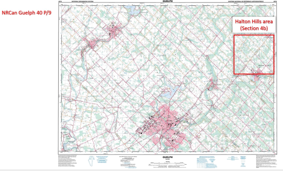
Part (ii) of Practical 2 applies the techniques and approaches developed in Practicals 1 and 2(i) to a geomorphological mapping and profiling exercise of the landscape and landforms in the Guelph Drumlin Field, c.40 km west of Mississauga. This will use topographic maps produced by Natural Resources Canada and photographic imagery from Google Maps (Streetview). There is no bounded study area for this exercise - rather, you are free to select a specific study area within the region covered by the NRCan topographic map sheet for Guelph. A broader introduction to the area will be covered in Lecture 6 (Glacial landscapes of Southern Ontario).
Resources (see Quercus Files/Practical Materials/Practical 2 folder)
• Natural Resources Canada Topographic Map 40 P/9 (Guelph): 1:50,000 scale - available as a pdf file (NRCan_40_P_9.pdf) and as hardcopy in the lab.
• Google Maps (Streetview imagery)
• A Powerpoint file (Guelph_Figure_3a.ppt) to use for Figure 3a (see below).
• Lecture 6 slides.
• Trenhaile, A.S. (1975). The Morphology of a Drumlin Field. Annals of the Association of American Geographers, v.65(2): 297-312.
• Sookhan, S. et al (2018a) LiDAR-based mapping of paleo-ice streams in the eastern Great Lakes sector of the Laurentide Ice Sheet and a model for the evolution of drumlins and MSGLs.
Geologiska Föreningen, 140(2); 202-228. (see section on the Halton Ice Stream, p.220).
• Sookhan, S. et al (2018b) Converging ice streams: a new paradigm for reconstructions of the Laurentide Ice Sheet in southern Ontario and deposition of the Oak Ridges Moraine. Can. J. Earth Sci. 55: 373-396. (Fig. 6, p.382 and search for mention of the Halton Ice Stream).
Instructions
An early but detailed analysis of the Guelph Drumlin Field was published by Trenhaile in 1975 and much of this area is covered by the NRCan 40 P/9 source map - see Figure below. It is recommended that you start by reading pages 297-301 for the general context and details of local drumlin sizes. More recent research on drumlin orientation and ice-flow directions for the region can be found in Sookhan et al (2018a and b). Complete sections 3 and 4 as described below.

Section 3
Take the time to familiarize yourself with the topography in the general area and especially in the Guelph-Rockwood-Ennotville area - you should take advantage of the full hardcopy and(or) PDF copies of the 40 P/9 source map and also Google Streetview imagery.
|
Section 3 exercise: Geomorphological mapping and virtual fieldwork (20 marks) a) Select any area measuring approximately 10 x 10 km on the Guelph map that you consider to represent a good example of a drumlinised landscape. Ensure that there are roads traversing at least one example of a drumlin, and that these roads have Streetview imagery. b) Present a location map of the study area on a full-size copy of the Guelph map provided as a Powerpoint file (Guelph_Figure_3a.ppt). Label this as Figure 3a. c) Crop an image of your chosen study area from the original Guelph map (Guelph_40_P09.pdf) and using this as a base map, draw directly on this figure to develop a geomorphological map of the landforms based on your interpretation of the contour data. You should focus on the most readily identified landforms but are free to attempt to identify and draw as many features as you can. Ensure you provide a suitable key for the features identified (refer to examples of geomorphological mapping discussed in the introduction to Practical 2i and in the reference list below for alternative mapping styles). Ensure that your map is provided with a scale and north arrow! Label this map as Figure 3b. d) Select a road that traverses one or more drumlins in your study area and construct a topographic profile along the road to show the relief of the features identified. The length of the profile will depend on your selected area of interest, and you may use either the contour method or Google Earth to develop the profile (see Practical 1 for techniques). Draw and label the profile line on Fig. 3b and present the profile as Figure 3c (use the pdf of 2mm graph paper provided if you have used the hand-drawn contour method). Ensure you provide a scale for the X and Y axes. e) Use Streetview to find viewpoints that illustrate the general relief and character of the drumlinised landscape along your topographic profile. Present one or more images as Figures 3d, 3e, etc. and provide captions explaining your choice of viewpoint. Locate and label your viewpoints on Figures 3b and 3c. |
Section 4
In Section 4 you will review the landscape analysed in Section 3 in the context of wider regional glaciation. Ensure you reference your Section 3 figures and supporting literature throughout.
(max. 300 words).
|
Section 4 exercise: Glacial streamlining and ice flow direction (20 marks) a) How does the landscape of your study area reflect glacial streamlining and ice flow direction in the Guelph Drumlin Field? Explain the contrasts between this landscape and the drumlinised landscape in the Peterborough area analysed in Practical 1. b) Account for the contrasts in the landscape of your study area and that of the Halton Hills area north of Acton (see figure below). |
Submission instructions
Submission should be online via Quercus (Assignments / Practical 2) as a single .pdf document that combines Parts (i-iii); submit by 9 pm, Friday 7th November.
References and other useful literature
• Trenhaile (2016). Chapter 7, p.223-236.
• Clark, C.D. et al. (2009). Size and shape characteristics of drumlins, derived from a large sample, and associated scaling laws. Quaternary Science Reviews, 28: 677-692.
• Evans, D.J.A. and Twigg, D.R. (2002). The active temperate glacial landsystem: a model based on Breidamerkurjokull and Fjallsjokull, Iceland. Quaternary Science Reviews, 21: 2143-2177.
• Livingstone, S.J. et al. (2008). Glacial geomorphology of the central sector of the last British- Irish Ice Sheet. Journal of Maps, 2008: 358-377.
• Knight et al (2011). Geomorphological Field Mapping. In: Smith, M.J. et al., Geomorphological Mapping: Methods and Applications. Elsevier. (Chapter 6).
2025-11-05