GEOS1003 /1903 Fieldtrip
Hello, dear friend, you can consult us at any time if you have any questions, add WeChat: daixieit
GEOS1003 /1903 Fieldtrip
Stop 1
1.1 Draw a geological sketch of the outcrop that includes the main features that you see.
Do you see any consistent patterns in the rock? Which shape do they have? Identify the rock type, what kind of rock is it? Sedimentary, igneous, or metamorphic?
Describe the textures and interpret the mineral composition.
N S
Scale
1.2 Draw a cross-section that shows the relationship between the Kiama Sandstone (red coloured sandstone that you can observe if you look to the south), the rocks you see in the quarry, and the yellow weathered rocks on the top of the quarry (yellow coloured unit at the north face of the quarry). Describe the relationship between the three units.
N S
Scale
1.3 List the order of events geological history for the Bombo Headland Quarry, starting from the oldest geological event. e.g. which unit was deposited first?
Stop 2
2.1 What kind of rock is it? sedimentary, igneous, or metamorphic? Identify the specific rock type. What is the overall grain size of the rocks? what can you infer about the energy of the environment in which they formed
2.2 We observe fossilised bryozoa and bivalves as well as shell fragments in the rocks, in which environment do you think these rocks formed?
2.3 Dropstones are isolated fragments of rock found within finer-grained rocks. Make a sketch showing the relationship between the dropstone and the rock surrounding them. Search online for how glacial dropstones form and draw a sketch showing how they form.
2.4 The prismatic features we see are called glendonites. They are originally composed of a mineral called ikaite (CaCO3.6H2O), which forms in the temperature range of-2 to 5ºC. Their characteristic prismatic shape remains after the sediments surrounding them become rocks and the ikaite is replaced by calcite. What can you interpret about the climate in which these rocks were deposited? were they formed in cold or warm waters?
Stop 3
3.1 What kind of rock can you identify along the rock face at the north end of Austinmer beach? sedimentary, igneous, or metamorphic?
3.2 Draw a geological sketch showing the different rock types you see in the outcrop and their relationships. How many specific lithologies do you see?
3.3 In which environment do you think these rocks formed?
3.4 What changed in the environment of deposition of these rocks and the ones you saw in Flagstaff Point?
Stop 4
4.1 What is the relationship between the changes in slope in the landscape and the different types of rocks?
In this region, the coastal rock platforms are mostly composed of Upper Permian Illawarra Coal Measures. The varied lithologies ofthe Narrabeen Group are exposed on the near coastal headlands and on the forested slopes leading up to the coastal escarpment. The thick sandstone unit that forms the capping to the escarpment in this region is the Middle Triassic fluviatile Hawkesbury Sandstone.
Make a geological sketch and draw the contacts between different rock units.
4.2 What processes are responsible for the landscape you see?
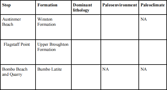
4.3 Fill out the table and write a brief summary of the paleoenvironmental and paleoclimatic changes you can infer based on the key observations we saw today
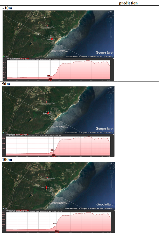
4.4 There is scientific and anecdotal evidence that sea-level has changed in the past and scientists have predicted it will change in the future. Make a prediction of what would happen
2025-11-04
Introduction to Geology