CVEN30011 Smart Transportation 2025 Assignment 2
Hello, dear friend, you can consult us at any time if you have any questions, add WeChat: daixieit
CVEN30011
Smart Transportation 2025
Assignment 2
Part I: Land Use & Transport Options
Part II: Level of Service (upcoming)
25 August 2025
Project Background (same asA1)
Imagine that you have been hired by a Local Government Area (LGA) in Metropolitan Melbourne to investigate how the new Suburban Rail Loop Line will serve and impact the area. The semester project involves an assessment of the area including the served population and their current travel alternatives as well as the proposition of complementary strategies that can enhance the benefits brought by the new line. Throughout the semester, you will work individually and in group to deliver the different components of the project as part of Assignments 1-3.
The LGA hiring your services will be determined based on the last digit of your Student ID. On the cover page of the deliverable, you should include both the full name and Student ID number of all group members and the name of the LGA. Groups should have between 3 and 4 students. All group members should (1) have Student IDs that match the same LGA and (2) be attending the same tutorial session.
• Student ID # ending with 0 or 1: Werribee Station – Wyndham LGA
• Student ID # ending with 2 or 3: Sunshine Station – Brimbank LGA
• Student ID # ending with 4 or 5: Broadmeadows Station – Hume LGA
• Student ID # ending with 6 or 7: Heidelberg Station – Banyule LGA
• Student ID # ending with 8 or 9: Cheltenham Station – Kingston LGA
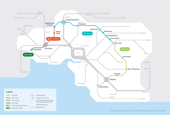
Figure 1: Suburban Rail Loop Plan (Source:https://bigbuild.vic.gov.au/projects/suburban-rail-loop)
The SRL will create direct connections between the following LGAs: Bayside, Kingston, Monash, Whitehorse, Manningham, Banyule, Darebin, Merri-bek (Moreland before 2022), Hume, Brimbank, and Wyndham.
For more information about the SRL project, visit: https://bigbuild.vic.gov.au/projects/suburban-rail-loop. Some additional information may be available within the relevant city council’s website.
Assignment 2 Task
In this task you will work in groups of 3 to 4 students. If you do not form a group by the 29th of August 23:59, the subject coordinator will allocate you to a group. You will be able to visualise the name of your teammates via Canvas once the groups are allocated. You can find each other’s contact information and use the discussion functionality to communicate. If you have issues contacting your team members, let the instructors know as soon as possible.
The SRL aims to improve the connectivity of Melbourne’s rail network, which is currently radial and requires travellers to go to the CBD if they want to reach suburbs served by different train lines.
In Part I of this assignment, you will analyse the land use and existing public transport options in your LGA. In Part II, you will compute level of service metrics and discuss the potential benefits of the new SRL line. You should use QGIS (or ArcGIS) to produce all the maps in the assignment. Maps should be exported from QGIS/ArcGIS and included in the report as an image.
This is a project and often you will need to make assumptions. This is a group assignment so that you can discuss these assumptions with your team, just like in your professional life. There are multiple possible ways of answering questions and they will be correct as long as they are clearly explained and in alignment with transport theory. Always explain your assumptions and methodology (including the calculations).
PART I (66 points)
Task A: Land Use and Activity System
1) Create a map of the LGA identifying its sub-areas based on their predominant land use zone type (commercial, industrial, residential, mixed use, public land, transport, rural, special purpose, other). Compute the areas for each sub-area and identify the predominant land use within the LGA. The map should include the LGA border and a legend with the 9 land zone types above. (8 pts)
2) Create a map that colour codes the 9 land use zone types into trip production zones (red), trip attraction zones (blue), or none (grey). What proportion of the LGA’s land is a trip attraction zone? Based on the relevant theoretical definitions, provide a justification to why each land use type should be classified as production, attraction, or none [150 words]. (6 pts)
3) Compare your results from Q2 with those from A1-Q2. Discuss potential reasons why the results align/differ [150 words]. (6 pts)
Task B: Public Transport Options
4) Create a map of the existing public transport network in your LGA. Identify the different public transport modes and services. Include the routes (and labels) and stops of these services in the map. If you find necessary, you can use an auxiliary table to show the service names. (10 points)
5) What services are more suitable to serve local trips (trips within the LGA)? Why? [100 words] (3 points)
6) What services are the best alternatives to travel from the LGA to Melbourne’s CBD? Why? [100 words] (3 points)
Task C: Service Coverage
7) To analyse public transport access and coverage, it is necessary to understand how far people are willing to walk to reach these services (walking threshold). Use the literature to identify an appropriate catchment area threshold for (i) bus and (ii) train services. Justify your choice providing references [150 words]. (4 points)
8) Using the thresholds selected in Q7, for bus and train, create a map and plot the service area (catchment area from all stops/stations) using isochrones or the buffer technique. Explain your choice between isochrone and buffer for each [100 words]. (10 points)
9) What percentage of the LGA area has access to each mode? (2 points)
10) What percentage of the trip production area has access to each mode? Interpret and briefly discuss this result [100 words]. (4 points)
Task D: Accessibility Measures
Compute the cumulative opportunities accessibility measure for the SRL station:
11) How many points of interest can be reached in 10 minutes by foot (walking)? Provide a map with your answer. (3 points)
12) How many points of interest can be reached in 10 minutes by bicycle? Provide a map with your answer. (3 points)
13) Interpret your findings from Q11&Q12 and discuss two additional accessibility measures that would be relevant to SRL planners [150 words]. (4 points)
2025-09-25