GGR201H5S Winter 2024 Practical Exercise 1 (Weeks 2-5): Topographic maps and glacial landforms Part ii
Hello, dear friend, you can consult us at any time if you have any questions, add WeChat: daixieit
GGR201H5S Winter 2024
Practical Exercise 1 (Weeks 2-5): Topographic maps and glacial landforms
Part (ii) Landscapes of glacial retreat - the Tschierva Glacier, Switzerland
Due: Monday 5th February, 9 pm
Outline & rubric
|
Practical class |
Assignment component |
Mark |
|
January 12th |
Part (i) Analysis of Topographic Maps / Glacial Landscapes (virtual fieldwork) Section 1 – interpreting contour maps Section 2 – constructing topographic profiles Section 3 – virtual fieldwork |
6 14 20 |
|
January 19th |
Part (ii) Landscapes of glacial retreat - the Tschierva Glacier, Switzerland Section 4a – topographic profiles Section 4b – glacial landforms Section 5 – timescales of glacier retreat |
20 10 5 |
|
January 26th |
Part (iii) Glacial landforms in the Peterborough area of Southern Ontario. Section 6 – topographic profiles Section 7 – glacial landforms |
15 30 |
|
February 2nd |
Parts (i-iii) (continued) Online submission by 5th February, 9 pm |
|
|
|
Total: |
120 |
Introduction
In Part (i) of this practical you were introduced to topographic maps, contour analysis topographic profiling (Sections 1-3). Part (ii) of the practical will return to the Roseg Valley virtual fieldtrip website (VR Glaciers and Glaciated Landscapes) to apply your knowledge of topographic profiling using contour data (developed in Parti) to explore glacial retreat in part of the valley (Sections 4a and b), and will also use analysis of historic topographic maps to establish the timing of glacier retreat (Section 5).
Objectives
After completion of this practical you should be able to:
1. Construct topographic profiles using contour data and describe them in the context of glacier retreat in the Roseg Valley.
Resources (online and Quercus: Practical 1 folder)
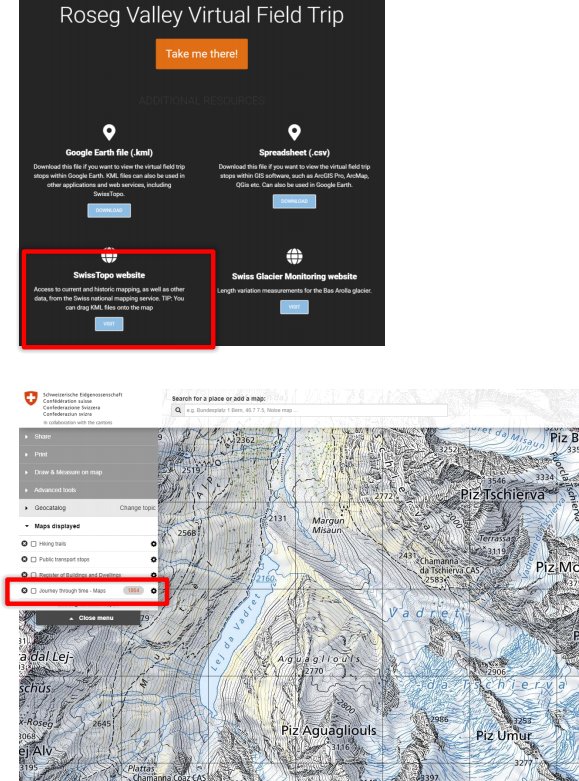
• The Roseg Valley Virtual Fieldtrip:
https://vrglaciers.wp.worc.ac.uk/wordpress/roseg-valley-virtual-field-trip/
Once on the web page scroll down and click ‘Take me there’ .
• Figs 4a-c: Topographic maps from the Roseg Valley (the Tschierva Glacier) (data from
https://map.geo.admin.ch). These are available as separate pdf files in the Practical 1 folder - Modules / Week 2 / Practical 1(ii).
• Trenhaile (2016) or equivalent texts (see below)
Figures 4a-c presents topographic maps of the lower part of the Tschierva Glacier and a prepared plotting graph as follows:
a) A modern (2018) topographic map of the glacier (contour intervals are 10m) showing profile line X-Y.
b) A map of the same area as (a) dating to 1880 (contour intervals are 30m), also showing the same profile line X-Y.
c) A prepared plotting graph with the X-axis scaled to the X-Y profile, and a vertical axis at 2x exaggeration.
Note that you should print Figs 4a-cat 100% scale in order to preserve the scaling of the profile line and the X-axis of Fig. 4c. It is recommended to use Adobe Reader to print rather than a browser since print scaling in the latter can be unreliable.
Section 4: Topographic profiles and landforms of the Tschierva Glacier valley (30 marks)
a) Using techniques developed in Part (i), Section 2, construct topographic profiles along the
profile line X-Y shown in both Fig. 4a and b. These can be drawn by hand, although you are free to use drawing software if you wish. Both profiles should be drawn on the same plot provided in Fig. 4c, and are scaled on the pdf’s so that the profile length (1500m) matches the length of the x-axis. Ensure that you differentiate and label each profile (2018 and 1880). (20 marks)
b) Note that the two profiles show the valley both while it was occupied by the Tschierva Glacier (1880) and after the glacier had retreated upvalley of the X-Y profile line (2018). On Fig. 4c
provide appropriate labels to identify the most prominent glacial landforms that remain after the ice has retreated from this locality. You may find Fig. 7.11 from Trenhaile (2016) useful here – see below. (10 marks)
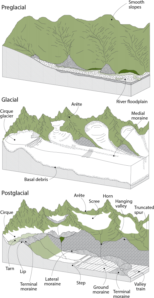 Trenhaile (2016), Fig.7.11
Section 5: Timescales of glacial retreat (5 marks)
Frequently updated topographic maps of this area allow the gradual retreat of the Tschierva Glacier to be tracked in detail from the late 19th C to the present. Using the link to the Swiss Topo website (https://map.geo.admin.ch/) from the Roseg Valley Fieldtrip page, click on the “Journey through time – maps” linkin the left-hand menu screen, and explore the various map editions available for the period between 1880 and 2018 (see images below). During which decade did the snout of the Tschierva Glacier retreat past the approximate line of the X-Y profile you have drawn in the sections above?
2024-02-05
Landscapes of glacial retreat - the Tschierva Glacier, Switzerland